
Driving thru Southern Maryland’s rural scenery- farms, woods, and villages, history greets you around every curve. Strong traditions in the heart of the people make it easy to appreciate the deep roots of that tradition. Villages and harbour scenes, rivers and marshland, lighthouses and beaches, historic sites and quiet churchyards; it’s no wonder they say: “Southern Maryland, where time and tide meet.”
Solomons Island lies across the Patuxent River from the Naval Air Station, near its confluence with the Chesapeake Bay. Solomons Island, along with Drum Point and Cove Point, anchor the peninsula between the Patuxent and the Chesapeake, which is Calvert County.
The Calvert County Tourist Information-Solomons Visitor Center is located at the foot of the Gov. Thomas Johnson Bridge over the Patuxent River, linking St. Mary’s County with Calvert County. Nearby, the fishing pier offers a great view of the bridge and riverfront. Across the street from the visitor center is a must stop- The Calvert Marine Museum. It offers a window on the history, culture and natural heritage of this region, through a variety of exhibits. Aquariums showcase local fresh and saltwater wildlife. A boardwalk allows visitors to see exhibits on marsh life in the tidewater area. Almost everyone’s favourite attraction is the otters. Three otters practice their playful antics to the delight of children of all ages. A cruise allows visitors to feel the salt air and see the shore from a different vantage point. A variety of boats on display tell the history of local fishing and commerce. Exhibits on regional history (including relics from the American Chesapeake Flotilla scuttled in 1814), culture and even fossils from the nearby Calvert Cliffs give the viewer an appreciation of the variety of experiences to be found in Southern Maryland.
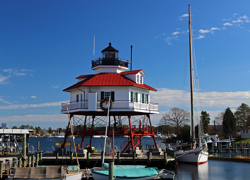
Drum Point Lighthouse (1883-1962) is a screw-pile type structure, and was located 125 yards off confluence of the Patuxent River and Chesapeake Bay. It had a fixed navigational beacon and 1400 pound fog bell and was moved to the museum in 1975. Tours are available (included in your museum admission), and offer a glimpse of the life of the keepers who helped keep maritime navigation safe. Nearby, the M.M. Davis Shipyard built outstanding wooden yachts from 1885-1974. Many, such as High Tide, Manitou, and White Cloud brought international fame to Solomons.
Taking Solomons Island Road South, visitors can drive across a bridge onto the actual island. On the left is J.C. Lore Oyster House. The building is now owned by the Calvert Marine Museum. The Lore company started packing oysters in 1888, and began using this site in 1912, with this building dating from 1934. Used until 1978, it is built on old discarded oyster shells, Continuing South towards Sandy Point, the road runs beside Solomons Island Boardwalk and Gazebo. This area has river views, seafood restaurants, and shops, as well as lodging such as the Blue Heron B & B, Solomons Victorian Inn B & B, and the Back Creek Inn B & B (c.1880). The end of Solomons Island features a beautiful view of the Patuxent flowing into the Chesapeake. This area houses the Chesapeake Biological Laboratory, which has furthered research into the natural environment of the region for nearly 100 years. The University of Maryland Center for Environmental Science also has a presence here. This makes Solomons not only a tourist destination, but a significant destination for scientific study. The British used Solomons as a base from which to raid the area, and eventually move up the Patuxent for their drive on Washington in 1814.
The On Watch Statue, overlooking Back Creek, commemorates the first U.S. amphibious training center, Solomons-Amphibious Training Base. Active from 1942-45, the center was located at the end of the Dowell Peninsula. It trained 68,000 men for landings in various World War 2 campaigns, including, interestingly, the Solomon Islands. Bricks surrounding the statue are engraved with the names of men and women who served in WW2.
Annmarie Sculpture Garden and Arts Center features not only exhibits and gardens, but classes, programs, and special events. Something for every season can offer visitors reasons to come back. The 30 acres of woods and meadows offer views of sculpture set amidst nature’s beauty. A butterfly garden, antiques, seasonal festivals and markets, internships, field trips-check out their website (annmariegarden.org) to plan your visit.
Recreational activities abound. Boat charters for fishing, sightseeing, or sailing are available to tackle the open bay or quiet creeks. Wineries offer tastings and are great sources of presents and souvenirs. There is even a Patuxent Wine Trail meandering through the pastoral scenery. A variety of breweries cater to those whose palate leans in a different direction. Perhaps nothing says Southern Maryland like seafood. A variety of restaurants offer their take on regional classics as well as more standard fare.
Cove Point Light Station is a restored 1828 lighthouse, keeper’s home and visitor’s center on the bay, and is now available to rent for your next getaway. The lighthouse was made of local brick and features an 1897 Parisian prism. In 1912 it was raised to 51 feet, and in 1953 concreted. Automated in 1986, its 150,000 candlepower beam is visible 21 miles away. It is run by the Calvert Marine Museum. Confederate sympathizers drove off Union troops looking for blockade runners in August, 1864.
Calvert County has 24 miles of cliffs that dominate the Chesapeake Bay. Captain John Smith would have passed these cliffs in his 1608 voyage up the Chesapeake. Calvert Cliffs State Park showcases this natural feature, and in addition has sandy beaches, fossils, fishing, and hiking trails. There is a day use fee at this park. Flag Ponds Nature Park features the Chesapeake Bay shoreline, with its ever changing, sandy landscape. Fossil hunting, beach combing, and observation platforms at the beach and ponds offer hikers a window on nature. The visitor’s center also has local wildlife displays. Nearby is Maryland’s first nuclear power plant, Calvert Cliffs. Lord Baltimore granted 1,000 acres to Richard Preston in 1658. Over 300 years would pass until Preston Clifts, or Charles’ Gift, was purchased as the site for the power plant.
Middleham Chapel, located just off Route 4 at Calvert Cliffs State Park, is a one-story, cruciform, Flemish bond brick Episcopal church, built in 1748. It replaced the log structure, Chapel of Ease of Christ Church Parish, which possibly dated to 1684. It shares a parish hall with St. Peter’s Chapel, an 1889 Carpenter Gothic-style Episcopal church located in Solomons.
Jefferson Patterson Park and Museum showcases nature and history. A shoreline nature trail and native American village reconstruction are popular features. The Colonial Revival Patterson estate is currently closed to visitors. The Maryland Archeological Conservation Laboratory also has a home here, features 65 archeological sites, and hands-on experiences at the museum. The exhibit barn houses a display on “Farmers, Patriots and Traitors: Southern Maryland and the War of 1812.” The gift shop sells educational merchandise including games, souvenirs, literature, arts and crafts. The park has a large research library featuring an extensive collection on Maryland and regional history and archeology. John Smith noted the many fascinating Indian cultures he found on his voyages. His 1608 expedition would have passed here as it explored the Patuxent.
A number of historical plaques at the park tell more of the history of the area. The naval battles between the British fleet and Commodore Joshua Barney’s Chesapeake Flotilla took place off the shore here where St. Leonard Creek meets the Patuxent River, and off nearby Broomes Island. Jefferson Patterson Park was the home of John Stuart Skinner, whom John Quincy Adams called a “Ruffian, Patriot, and Philanthropist.” Learning about this amazing man is worth a stop by the park. He was with the American flotilla of Commodore Barney, and rode to Washington with the news that the British were coming, for which he is called “Maryland’s Paul Revere.” He published several early American periodicals on agriculture and sporting activities. He accompanied Francis Scott Key when he went to the British to obtain the release of Dr. Wiliam Beanes. They observed the bombardment of Ft. McHenry together, and Skinner was the first person to whom Key showed his poem which became the Star Spangled Banner. The British burned buildings on his property which is now the site of this interesting park.
Morgan Hill Farm, known as Morgans Fresh when granted in 1651, belonged to Philip Morgan, a captain in the Puritan militia. The house, which may have dated to 1670, overlooks St, Leonard Creek and was a lookout post during the War of 1812 as well as the Civil War. St. Leonard’s was originally located at the mouth of St. Leonard Creek, in 1683, and was a port of entry at the head of the creek by 1706. The wharves and warehouses were burned by the British in 1814, and after 1900 the town was located a few miles North.
Nearby were a couple of notable manors. Brewhouse, first surveyed in 1651, was the birthplace of Gov. Thomas Johnson in 1732. As a member of the Continental Congress, he nominated George Washington as Commander-in-Chief of the Continental Army in 1775. He was governor of Maryland, and later a justice on the U.S. Supreme Court. Preston on the Patuxent was the home of Richard Preston, commander of the North Bank of the Patuxent River. It was the seat of Puritan government in Maryland (1653-57) and repository of the colonial records.
Just over a mile South of Port Republic, on Broom’s Island Road, is the historic marker for Veitch’s Cove, later Veitch’s Rest. Named for James Veitch, a settler from Scotland. Lord Baltimore, in 1649, granted the original land patent. Veitch was sheriff of Calvert County in the 1650’s.
A couple of miles up Route 4 from St Leonard is Port Republic. Christ Church is the oldest continually worshipping Episcopal congregation in Calvert County. It was one of the 30 original Anglican parishes in Maryland. The current church dates from 1772, but a former log church was used as early as 1672. Just to the west of Port Republic visitors find Battle Creek Cypress Swamp Sanctuary. It is one of the northernmost bald cypress stands in America and boasts a boardwalk, nature trail, and exhibits on wildlife and cultural history.
Nearby Biscoe Gray Heritage Park features natural and cultural resources which explore the farming practices of Calvert County from native American times through the centuries. A 150 year old trace, woodlands, marsh and cultivated uplands helps students learn about the Chesapeake region’s ecosystem. Check for special events to take advantage of the rich cultural and natural resources of the area.
St. Paul’s Episcopal Church was organized in Prince Frederick, in 1841. The first service was held on Christmas Day, 1842. Fire destroyed the courthouse in March, 1882, and the church served that function for a time. Ironically, another fire in June, 1882 burned the rectory. The parish house was rebuilt in 1883.
Prince Frederick was chosen in 1722 as county seat for Calvert County. The town was probably named for Frederick, the son of George ll. The original courthouse was completed in 1732. During the War of 1812, while the British tried to capture Commodore Barney’s flotilla, they raided the area and burned the town in June, 1814. After the 1882 fire, which destroyed much of the town, a new courthouse was built on the same site,and is still in use today. Prince Frederick boasts a connection to Sir Isaac Newton. A historical marker near Calvert High School tells the story of Arthur Storer (C.1642-1686), the first astronomer in America. From here Storer, who immigrated from England, observed and took notes on the return of Halley’s Comet in 1682. His friend and colleague, Sir Isaac Newton, often quoted Storer in his scientific works. The Arthur Storer Planetarium is on the grounds of Calvert High School.
Near the high school, also raided by the Brithish, is The Reserve. According to the Maryland Historical Trust, this 19th Century tobacco plantation features a frame dwelling built shortly after the War of 1812. The property is also associated with John Stuart Skinner.
Just North of Prince Frederick, is a marker for Joseph and James Wilkinson, who grew up on a farm on Hunting Creek a few miles West of Route 4. Joseph was a colonel in the Revolution, and a legislator. James was promoted to the rank of general at age 20, in 1777. James became General-in-Chief of the Army and Military Governor of Louisiana (1805-07) He was implicated, but acquitted, in the Aaron Burr conspiracy. Both brothers served in the War of 1812 as generals. Joseph is buried in the family graveyard.
Dare’s Beach is a bayside resort with a wonderful view of the Calvert Cliffs. After Puritans originally were granted land in the area in the mid 17th Century, it was one of the earliest areas settled by Quakers. This area was also the scene of a clash between Americns and British during the War of 1812. Nearby Parkers Creek Wildlife Management Area helps preserve area natural habitat. Hiking trails offer access for hikers, birders, and hunters. Educational and natural heritage programs help to educate the public on environmental issues. The area was named after William Parker, a founder of Anne Arundel County, who obtained a patent to land along the creek in 1651 (Parkers Cliffs) The area later became a center of African-American settlement, with logging, farming, and fishing providing sources of income. Trees cut for ties were shipped by steamships on the bay.
The American Chestnut Land Trust (Acltweb.org) also helps preserve the natural as well as cultural resources in this area. Through their watershed awareness program, stewardship education, scientific study, and trail upkeep help to involve the community in study and preservation of the area’s ecosystem. Nearby Hunting and St. Leonard Creeks also have community groups interested in preserving the ecology of those areas.
Chesapeake Beach has long been a destination for getaways. The Chesapeake Beach Railway, the Honeysuckle Route, connected the area to Washington, D.C. from 1897 until it failed during the Depression. The old station is now a museum, featuring exhibits and photos of the bayside resort during its heyday. A boardwalk follows Chesapeake Beach Railway Trail for over a mile along Fishing Creek, a great way to view wildlife. Otto Mears intended the railroad and steamships from Baltimore to bring tourist to enjoy the boardwalk, casinos, race track, band stand, rollercoaster, and carousel. Today, the area still has much to offer, featuring a waterpark, nature trails, fishing, boat charters, and of course, seafood and the beach. “Charter Boat Row” is considered the charter fishing capital of Maryland. A model railroad club has been formed to create a model for the museum so visitors can see the railroad during its glory days.
Bayside History Museum in nearby North Beach showcases the cultural, historical and natural heritage of the area. There is even a display of reproduction, carved carousel animals that harkens back to the old Chesapeake Beach Amusement Park. Near the museum, Westlawn Inn hosts diners much as it did 90 years ago, often to live music.
Just off Route 4 in Dunkirk we find the oldest standing Methodist church in Calvert County. Smithville United Methodist Church was dedicated in 1840, with bricks and much of the interior woodwork made by members in the 1880s. This circuit began in the 1780’s, with services held in homes. It had at that time the largest membership of any circuit in the U.S. A few miles South, in Sunderland, we find All Saints Episcopal, one of the original parishes of Maryland. The present church was started in 1774 by Rev. Thomas John Clagett, later the first bishop consecrated in America. An important chapter in education has roots in Sunderland. Harriet Elizabeth Brown challenged separate salary scales for public school teachers based on race in 1937. It was a turning point for salary equalization in Maryland
Also South of Dunkirk, on the Patuxent River, lies the village of Lower Marlboro Town.
Named Cox Town in 1663, after settlers Thomas and Henry Cox, it was renamed after the Duke of Marlborough following his defeat of the French at Blenheim, which reduced tensions on the American frontier between the British colonies and the French and their Indian allies. An early port of entry, it grew during the 18th Century, and added lower to its name to distinguish it from the Prince Georges County seat. Patuxent Manor (Grahame House) stands nearby. Charles Grahame was associated with the Calverts and Gov.Thomas Johnson. The manor, dating to the 18th Century, is one and a half story with Flemish bond style brick. One renovation led to the fine paneling in the house being displayed in the Winterthur Museum.
Calverton Taney Place (now Taney Place Farm-200 Years of Family FarmTradition) has gone from a traditional tobacco farm to wheat, soybeans, and hay, as well as all natural Angus beef, pasture raised pork and eggs. Taney Place Farms Labradors are a recent project. The tenth generation is now growing up on the farm, and good stewardship is a family tradition. As one member has said, “No one will ever own Taney Place. We are merely caretakers for the next generation.” The house, c.1750, is a Georgian-style, hip-roofed country manor. It is also the birthplace and boyhood home of Roger Brooke Taney, who was Chief Justice of the U.S. Supreme Court from 1836-64. Nearby, across Battle Creek, was the site of Calvert Town, the first county seat, established by Robert Brooke in 1652. Established as Patuxent County in 1654, it was changed to Calvert in 1658. Now the smallest county, at one time it encompassed parts of Prince George, Anne Arundel and St. Mary’s Counties.
The importance of waterways for an agricultural society which depends on exports cannot be overlooked. Rivers such as the Patuxent were the connection plantations and farms depended on to ship produce such as tobacco to markets. Wharfs and landings were numerous, and necessary. It is no wonder that the British targeted these and farm buildings to damage the local economy. Sheridan Point Wharf, Hallowing Point, Holland Cliff Wharf, Lower Marlboro, Huntingtown,Taney Place, Broomes Island, Prince Frederick Courthouse were all targets of British raids, from both water and land forces.
A few miles down the Patuxent, Kings Landing Park offers many activities, from primitive camping to equestrian facilities. Fishing, canoeing, kayaking and hiking present opportunities to get close to nature. Wayside exhibits funded by the Chesapeake Bay Gateways Network educate visitors about the river and wildlife. The area has welcomed visitors since before John Smith passed this way. Calvert County boasts several water trails for canoeists, kayakers and sailors of all stripes who want to see Calvert County from the water, just as John Smith did over 400 years ago.
dnr.maryland.gov is the site of the Maryland Department of Natural Resources, and has information on water trails, both along the Patuxent and some of its tributaries and parts of the Chesapeake. It also has useful information on boating and fishing regulations, as well as paddling safety tips.
Chesapeakebay.net is the site for the Chesapeake Bay Program. It is the place for learning the latest efforts by governmental and private entities to help preserve and restore this natural wonder.
mht.maryland.gov is the site of the Maryland Historical Trust, which has a wealth of useful information, including an online guide to historical markers. HIstorical markers provide local historical information, and can make a drive thru the region a way to connect with the past. Check museum, historic sites, and other points of interest to see if they have websites. These will provide the latest information on hours and special events
The Star-Spangled Banner National HIstoric Trail, nps.gov/stsp, has the latest information on the natural, cultural and historical sites of the region relating to the War of 1812. The Patuxent River is part of this trail.
Whether your taste leans towards seafood or farmers’ markets, wine or beer, ethnic or regional cuisines, you are sure to find options in Southern Maryland to delight your palate. A variety of festivals celebrate maritime heritage, local arts and crafts, oysters and more. Lighthouses, villages, and fishing boats; marsh, river,beach, and bay; historic sites, museums, farms, and wineries- all await discovery by visitors driving thru Southern Maryland.
Tell the historic site, museum, farmers’ market, restaurant, or winery that you are there because the Abbeville Institute encourages us to celebrate Dixie. Tell them how to access Abbeville. We must always be ambassadors as we drive thru Dixie. We must build a community, one neighbor at a time. As Brion McClanahan would say, “Think locally, act locally!”
somdtrails.com is the site for Southern Maryland Trails, a guidebook of handmade, homegrown, and authentically Southern Maryland experiences.
General tourist information can be found at:
Md-calvertcounty.civicplus.com
Destinationsouthernmaryland.com