
The Chesapeake Bay is the heart of Maryland. Except for a couple of remote areas, all of Maryland drains into the Chesapeake or its tributaries. Most of Maryland’s population is little more than an hour’s drive, or less, from the bay. St. Mary’s City, where Maryland was ‘founded,’ is a few miles from the confluence of the Potomac River and Chesapeake Bay, though the first settler was William Claiborne who, in 1631, was living on Kent Island further up the bay.
The first few years after the settlement of Jamestown in 1607 saw explorations by Captain John Smith of much of the Chesapeake Bay area. Smith, in describing the bay, wrote in his journal, “heaven and earth never agreed better to frame a place for man’s habitation.” The Captain John Smith Chesapeake National Historic Trail, launched in 2007 as the nation’s first water trail, allows the intrepid adventurer to sail or paddle in the wake of Captain Smith. Twelve explorers, in 2007, did just that, in a 28-foot open boat powered only by sail and oar. This expedition, retraced Smith’s 1608 route. It was a program of the Sultana Projects, of Chestertown, Maryland, which is an educational foundation dedicated to the study of the natural and cultural resources of the area. The 3,000 mile water trail explores the Chesapeake (which means’ great shellfish bay’ in Algonquin) and the rivers which feed it.
“Since then, the trail has been extended beyond the route of Smith’s explorations to include the rivers and the upper reaches of rivers that served as trade and transportation routes for Indian tribes who lived here before the English arrived.There are countless things to see and do along the trail. The water routes offer great experiences for paddling and power boats, and there are lots of land-based sites to visit by car. You’ll find opportunities for boating, hiking, bicycling, and watching wildlife, as well as historic settings with museums, living history exhibits, and visitor centers. Many sites along the trail offer several of these options in one setting or in a cluster of nearby sites.”
The trail’s website, www.SmithTrail.net, is a great place to plan your adventure, and find the latest information on the trail sites. A series of ‘smart buoys’ have been developed and are being deployed, which will provide current weather conditions, as well as local historic and cultural information. These can be accessed at www.buoybay.org. This trail promises to offer the modern adventurer a taste of Captain Smith’s explorations.
The Chesapeake Bay Gateways Network is a partnership between the National Park Service and museums, wildlife refuges, parks, historic sites and trails, which invites visitors to explore the rich diversity of culture, nature, and history which is the Chesapeake Bay. Preservation of this great resource is underway by federal, state, and local governments. Many organizations such as the Chesapeake Conservancy, Chesapeake Bay Trust and the Chesapeake Bay Foundation, are working to save this national treasure from the damages wrought by overdevelopment of the surrounding area.
St. Clements Island, now a state park, lies a few miles up the Potomac River from the bay. Located just off the Maryland shore, near Coltons Point, it is served by a water taxi during summer months. The park honours the first settlers in Maryland who used the island as a base as they explored the area for a suitable settlement site. Hiking, picnic pavilions, and birdwatching attract visitors. A 40 foot cross, placed during the tricentennial of Maryland’s founding, also commemorates the first Catholic mass in the English speaking colonies, celebrated by Father Andrew White. A replica of the Blakistone Island Light is on St. Clements Island, replacing the original which burned in 1956. The original light, completed in 1851, was the object of a Confederate raid in 1864 which disabled the light.
St. Clement’s Island Museum tells the story of the arrival of English settlers in Maryland in 1634, and is located near the water taxi at Coltons Point. It features the story of Potomac River watermen, the Blakistone Island Light history, and has a Potomac River Dory Boat Exhibit, The Little Red Schoolhouse, located on the museum grounds, is typical of the 19th Century one-room schoolhouses found throughout the country. This building, from St. Mary’s County, helped rural students learn the basics, something which sadly many schools today are failing to impart. The museum also has a gift shop, perfect for souvenirs.
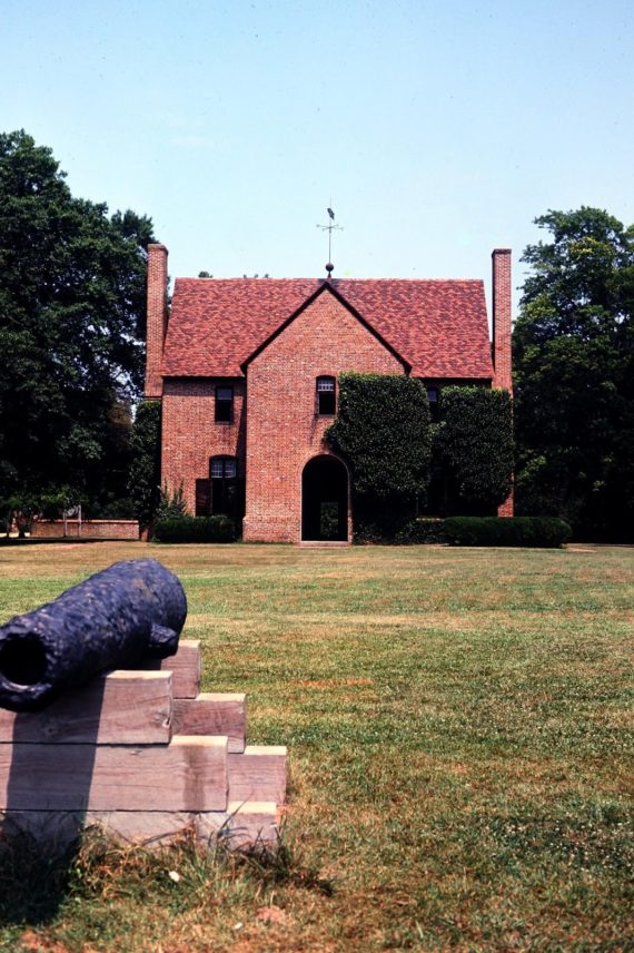
A few miles above the Chesapeake Bay, on a tributary of the Potomac River which they called St. Mary’s River, colonists found a site for their settlement. Historic St. Mary’s City celebrates the colonial origins of Maryland with an historic village reconstruction, park, and the Chancellors Point Natural History Area. These form an historic, cultural and natural museum combining indoor and outdoor exhibits and activities. This is one of the largest colonial capital sites that is interpreted with exhibits, reconstructions and living history. The visitor’s center is the best place to start your journey back into Colonial Maryland. Here you can get a map, information on current programs and events, as well as information on recent archaeological projects.
Learn the traditions of holidays past; attend lectures, demonstrations, guided tours, concerts, and workshops. See the St. Maries Citty Militia muster, learn how archaeologists uncover the past, taste colonial cooking, or learn how natural plants were used for dyeing different colours.
Visit the Shops at Farthing’s Ordinary, the museum’s place to shop for souvenirs, reproduction colonial items, and books on Maryland history.
The Inn at Brome Howard is an 1840’s inn, a National Historic Landmark, and a great place for a luxury getaway. Located on St. Mary’s River, amid the beautiful fields and woods of this historic site, it is popular for weddings, corporate events, or just a family adventure.
St. Mary’s Female Seminary was founded in 1840 as a finishing school for women. Calvert Hall, the first building on campus, has brickwork which dates to the 1840’s. St. Mary’s College of Maryland is a liberal arts college, one of only two public honours colleges in the country. Students are guided by the “St. Mary’s Way,’ a guide to strong core values, including open dialogue, respect for other views, respect for the natural environment, and a commitment to build a sense of community. A sense of tolerance harkens back to the founding of the colony of Maryland on these very acres. With a major historic site a part of the campus, opportunities such as the Archaeology Field School offer a chance to explore the past. Over 200 digs have been undertaken in the past 30 years. Environmental studies benefit from the proximity to the Chesapeake Bay ecosystem. The tradition of religious tolerance and democratic government have deep roots on these grounds, and offer students food for thought.
The Leonard Calvert Monument on Church Point marks the site of the ancient mulberry tree under which Leonard Calvert, Maryland’s first governor, negotiated with the chief of the Yaocomico village to purchase the land for the colony. Trinity Episcopal Church, located nearby, was originally built in 1638 in Ridge, Maryland. The wooden structure was moved in 1642 to St. Mary’s City, but by 1695 the old state house was being used for worship services. In the 1830’s, renovations using some bricks from the old state house, and a later structural change from a two-story Georgian to a one-story Gothic Revival style, created the current structure. Some interior details are made from the ancient Mulberry Tree. The foundations of the original State House are marked with granite. Celebrating Maryland’s 300th Anniversary in 1934, the 1676 State House was reconstructed. The original site is a nearby cemetery, so it occupies an adjacent lot.
The Maryland Dove, a rebuilt 17th Century coastal trading vessel, invites visitors aboard this pinnace to explore maritime history. This reproduction is similar in size to the Dove, the smaller of the two ships which brought colonists to Maryland. Launched in 1978, is owned by the State of Maryland, and is available for receptions through Historic St. Mary’s City. Docks have occupied the site of Bonnie’s Wharf, since the 1840s, when this was a major steamship stop between Washington and Baltimore. Union forces destroyed the original dock because of suspected Confederate smuggling.
St. John’s Site Museum houses the excavated remnants of an early plantation. Exhibits showcase some of the million artifacts found during excavations. The original building was owned by the colony’s first Secretary of State, John Lewger. The building had been used by the Maryland legislature, as a home for Governor Charles Calvert, and as an inn.
Garrett Van Sweringen’s Inn was the fanciest hotel in Maryland during the 17th Century. The kitchen and cellar have been reconstructed, and a simulation of the inn built as a museum. Van Sweringen, a Dutch immigrant, left the inn to his son, along with a neighboring structure. Archaeologists determined this outbuilding was one of English America’s earliest coffee houses. This building is represented as a ‘ghost’ frame.
Archaeologists have discovered the remains of Governor Calvert’s house, which saw much of Maryland’s early history. It bears witness to the only direct physical evidence of the English Civil War in America- it was surrounded by Pope’s Fort in 1645. In 1662, the colony used it as Maryland’s first State House, renaming it the Country’s House. After the construction of the 1676 State House, this was Maryland’s largest inn. Some of its brick chimney bases have been rebuilt, and some walls outlined. Cordea’s Hope, nearby, is a reconstruction of a merchant’s storehouse and office, and serves as a living history exhibit. Mark Cordea, a French immigrant, bought the lot in 1674. In addition to being a merchant, he served as a city alderman.
Town center ‘ghost’ frames in this area mark where archaeologists have found foundations, but at the present time do not know the exact use of the original structure. We know the location of Smith’s Ordinary, which burned; the site was then bought by Van Sweringen, who built a shop used by the first printer in the colony. We know this from the print type found at the site.
The Brick Chapel, built by the Jesuits in 1667, was the first major brick building in the colony. It was used for decades until it was demolished in 1725. Archaeological research has allowed this symbol of religious liberty to be reconstructed. A pavilion nearby has interpretive information on the archaeology and reconstruction. Another ‘ghost’ frame marks the site where archaeologists found a cellar, and dated it to early 18th Century. Since the Brick Chapel was closed in 1704, and Catholic services were allowed inside private homes, this c.1710-30 dwelling may have been used for that purpose.
The Mackall Barn is the oldest building standing in St. Mary’s City, and tree ring dating of the timbers shows it to date from 1785. It has been used as a granary, tobacco barn, and today serves as a museum exhibit about architecture and the period of decline after the capital moved away. Nearby, a woodland Indian hamlet tells the story of the Indians of the Chesapeake region. The good relations between colonists and the Yaocomico Indians was a very important factor in the success of the colony.
Godiah Spray Tobacco Plantation represents life on a typical plantation, c.1667. The name is fictitious, but this site presents the typical structures, fields, and livestock of the period, and is based on the records of a true planter family, that of Robert Cole. His will and inventory have given valuable details on everyday life on a Maryland tobacco plantation.
Colonial Maryland was the site of important firsts. One such event involved the Maryland Assembly, the case of Mathias de Sousa. De Sousa was of African and Portuguese descent, and came to Maryland as an indentured servant. After his indenture, he was a fur trader and mariner, and by 1642 was commander of a trade vessel owned by Provincial Secretary Lewger. He served at this time in the assembly of freemen, making him the first man of African descent to serve in an English assembly.
Another first involved Margaret Brent, a respected business woman in the colony. She was executrix of Gov. Leonard Calvert’s estate. She requested that she be named attorney in Maryland for Cecil Calvert , Lord Baltimore (his brother Leonard had served as his Attorney, also) The Provincial Court granted her request. Brent then went before the Assembly in 1648 and asked for two votes, one for her as land owner and one as attorney for Lord Baltimore. She was the first woman in America to request the right to vote. In 1915 Maryland suffragists journeyed by covered wagon from Baltimore to St. Mary’s City to gain support for women’s suffrage. This was known as the Margaret Brent Pilgrimage.
A Coast Guard Station and the Naval Electronics Systems Engineering Activity are situated across St, Inigoes Creek from St. Mary’s City. St. Ignatius Roman Catholic Church, built 1785-87, has Flemish bond brick walls nearly 2 feet thick. Relics from the colonial ships the Ark and the Dove are housed in the church. It also features a stained glass window depicting a local Indian chief who converted to Christianity and was a member here in the 1640’s. The smallest federal cemetery is located at the USS Tulip monument in St. Inigoes. The vessel left St. Inigoes in November, 1864 headed for the Washington Navy Yard. Her boiler exploded, killing most of the crew of 57.
Point Lookout State Park, just a few miles down State Route 5 from St. Mary’s City, commemorates the federal prisoner of war camp, which housed upwards of 52,000 Confederate prisoners of war, with nearly 4,000 dying. The Civil War Museum/Marshland Nature Center offers visitors a glimpse of the history of the area, as well as information on the natural environment. The park has a swimming beach, fishing pier and park store. The peninsula which ends in Point Lookout, the point where the Potomac River enters Chesapeake Bay, has a richer history than simply being a POW camp.
Captain John Smith passed the point in 1612 on his voyage of exploration. It was not only included in the grant to the Calverts, but in 1634 it was chosen by Maryland’s first governor, Lord Baltimore’s younger son, Leonard Calvert, as his manor. The British raided it both during the First War for Independence and in 1812. Americans used the point as a lookout to watch British fleet movements in the lower Chesapeake in 1814, sending the information by post riders to Washington. The British later used it as a base. The lighthouse, original parts dating to the 1830’s, is currently closed for further renovations. First used by the Union as a hospital, as the number of captured Confederates grew in 1863, they were sent to prison camp. Nearby the Veterans Administration oversees Point Lookout Confederate Cemetery. Adjacent to the cemetery is a Confederate Memorial Park with flags honouring the sacrifices of Confederate POWs, both military and civilian.
Maryland’s occupation by Federal troops limited its contributions to the Confederate cause. Volunteers had to leave the state to join the Confederate military, and many Confederate activities had to be underground. Smuggling medicine, supplies, and escaped prisoners were not uncommon. Southern Maryland was especially pro Southern, with many of its leading citizens being jailed for their political views.
The Elms Environmental Education Center, located on the Chesapeake Bay not far from St. Mary’s City, supports educational opportunities for the St. Mary’s County Public Schools. Nature programs, a native plant nursery, and public events seek to “inspire a life-long stewardship of our natural resources beginning in our own backyard: the Chesapeake Bay Watershed.”
St. Mary’s River State Park lies between Rt. 5 and Rt. 235. It is divided into two sections in the upper reaches of the watershed, popular for hiking, biking, and horseback riding. One section features 250 acre St. Mary’s Lake, popular for fishing. The second section has woodland, fields, streams, and swamps, and is managed for hunting, by permit.
Naval Air Station Patuxent River has been located in St. Mary’s County since 1943, and is known as the place “where the future of naval aviation begins.” Located on Rt. 235 near Lexington Park, NAS Pax River hosts the Naval Air Systems Command and Naval Air Warfare Center Aircraft Division among other activities. It consists of the main station at Lexington Park, Webster Outlying Field in St. Inigoes, Naval Recreation Center Solomons in Calvert County, and Bloodsworth Island Range in the Chesapeake Bay. Patuxent River Naval Air Museum features exhibits which tell the continuing story of naval aviation research, development and testing. It also has an exhibit on Maryland’s first naval engagement of the War of 1812, the Battle of Cedar Point. The museum’s mission is to “Preserve, Educate, Inspire.” Since 1978, the museum has been fulfilling its mission at the gates of NASPR, funded by a private foundation. The St. Nicholas church dates back to 1916, though the first church at the site was built in 1796. Father Andrew White located a Jesuit mission here in 1637 on land given him by Chief Macquacomen of the Mattapanient Indians.
Greenwell State Park, located off Rt. 235 on the Patuxent River offers hiking, horseback riding, fishing, and kayaking opportunities, as well as a picnic area. Nearby, also on the Patuxent River, is Historic Sotterley Plantation-c.1703. Guided tours of the manor house, nature and historic trails, seasonal programs, school outings, and special events make this a tremendous cultural resource for Southern Maryland. The goal of preserving structures and the natural environment, telling the story of the past, and serving as a link to America’s complex history is accomplished through 100 acres, 6 miles of trails, a Greek Revival Garden, 20 buildings, an 1830’s slave cabin, and a museum store with local crafts, educational books and souvenirs. A National HIstoric Landmark, this is an excellent place to learn more of the region’s museums, sites, and historical markers, especially relating to the War of 1812.
Trent Hall Farm, a few miles upriver from Sotterly, is a working farm and bed and breakfast, offering 300 acres of scenic beauty on the Patuxent River. The land was granted to Thomas Truman in 1658, and the house dates from 1789. British forces landed here in July, 1814 and raided nearby farms, destroying much tobacco. The site offers hiking trails, beaches, with restored marsh and wetlands with great bird watching opportunities.
Piney Point LIghthouse Museum and Historic Park, located a couple of miles up the Potomqc from St. Mary’s River, offers visitors a look at a different aspect of local history. It features the oldest of the few remaining lighthouses on the Potomac, which dates from 1836. The story of the lighthouse keepers and the Coast Guard offer visitors a window on the past when navigation was dependent on man rather than technology. Separate from the lighthouse museum, but nearby is the Potomac River Maritime Museum, offering a maritime history of this important waterway. A guide must be obtained to access to the lighthouse, which is a short stroll down the road from the museums. An interesting part of this park is Maryland’s first historic shipwreck dive preserve, the German submarine Black Panther U-1105, which was sunk in the Potomac River nearby.
A few miles above St. Mary’s River Park, just off State Route 5, lies Leonardtown, St. Mary’s County seat. McIntosh Run and Breton Bay connect this port with the Potomac. Originally called Seymour Town in honour of Gov. John Seymour, the name was changed in 1728 to honour Leonard Calvert, the colony’s first governor. The Old Jail Museum houses artifacts relating to county history. The jail keepers quarters are downstairs, with prisoners cells upstairs. A cannon from the colonist’s ship, the Ark, is displayed on the grounds. Tudor Hall, c. 1744, and enlarged in the 1760’s, is a Georgian style house with an inset portico and hanging staircase, among other features. It was home to Phillip Key, uncle of Francis Scott Key. It houses the St. Mary’s County Historical Society, and archives many collections of historical and genealogical records. Leonardtown Wharf Park offers beautiful views of the harbour. For over 50 years, in October, the National Oyster Shucking Contest and Festival (one of the nation’s oldest oyster festivals) showcases the rich seafood resources of the area.
Newtowne Neck is a peninsula South of Leonardtown, between St Clements and Breton Bays.
There has been a Jesuit presence in this area since 1688. Behind the current St. Francis Xavier parish church is the historic Newtowne Manor House c.1789. A group has been formed and is in the process of restoring the structure. The Newtowne Neck State Park encompasses nearly 800 acres of woods and waterfront offering excellent fishing, hiking, biking and nature watching. It is also part of a project to offer paddle-in camping, providing a secluded ‘backcountry’ experience.
This area was granted to William Bretton in 1640, who sold it in 1668 to the Society of Jesus for 40,000 pounds of tobacco. They cared for the property until 1967.
Ocean Hall, located in Bushwood, dates back to 1670. Though many alterations have changed the interior, some of the original Flemish bond brickwork remains in the outside walls.
Situated on several acres overlooking the Wicomico River, this is a popular event venue.
Further up the Wicomico, Christ Episcopal Church has been active for 300 years, now located in Chaptico. Gov. Charles Calvert visited the Chaptico Indians here in 1663. Chaptico, founded in 1683, was one of four ports of entry for St.Mary’s County. British raiders did much damage here in July, 1814.
Charlotte Hall, located off Rt. 5 as it leaves St. Mary’s County, was used as an American muster ground for militia. Charlotte Academy (originally Charlotte Hall School) is now the Maryland Veterans Home for disabled veterans and veterans affairs clinic. The school, founded in 1774, educated youth until 1976 Coole Springs of St. Marie’s were thought to have healing properties, which led to the establishment of one of the first hospitals in North America.
The Chesapeake Bay region was a major theater in the War of 1812, with Maryland seeing many skirmishes, battles, and raids. British naval forces did more damage in Maryland than any other state during the war. American land and naval forces had little success in stopping the British, except at Ft. McHenry, near Baltimore. The British Invasion which burned Washington City sailed up the Patuxent River, disembarked near Benedict, and marched overland on a raid famous for the burning of the White House. But these better known actions were outnumbered by skirmishes, British harassment of civilians and the destruction of property. With a fleet in the Chesapeake, these raids took British forces up rivers to strike at Maryland’s civilians, as well as trade and military facilities.
St Mary’s County saw many actions. Moving up the Potomac, British raids hit St. Inigoes Manor, St. Ignatius Roman Catholic Church, Porto Bello, and St. George’s Island on the St. Marys River. (St. George’s Island had seen British troops in 1776. Capt. Rezin Beall was wounded repulsing an attempt by British under Lord Dunmore to cross to the mainland while British vessels raided up the Potomac during the American Revolution.) British targets in 1812 included Breton Bay, St. Clement’s Island and Bay, and sites further inland such as Chaptico, Tudor Hall near Leonardtown , Mulberry Field and the Great Textile Mill Factory.
The Patuxent River was also an avenue for British raids, as well as being the route their forces took when they marched on Washington, D. C. Targets of British raids included Cedar Point, Carol Plantation, Scotch Neck, Coles Landing, Rousby Hall and Point Patience. There was a skirmish at St. Jerome Creek on June 1, 1814, as Capt. Josua Barney’s Chesapeake Bay Flotilla chased a British schooner until it came under the protection of larger ships of the British fleet. Long range firing between American and British naval forces did no damage at Cedar Point. The out gunned American flotilla retreated up the Patuxent River to the safety of shallow water in St. Leonard’s Creek. American attempts to slow the British invasion failed. Eventually, with help from land forces, the American flotilla passed the British ships and fled up the Patuxent. The inferior American flotilla was eventually scuttled, however, with their crews joining American land forces trying to defend Washington. Calvert County, across the Patuxent River, also has many sites which were also raided by the British.
A must for visitors driving off the beaten path, seeking local history, is the Maryland Historical Trust. It is a great source of information on museums, monuments, and historical markers. Their marker guide lets you read the history as you pass by markers on Maryland roads. Whether rambling through rural vistas, enjoying waterfront seafood, climbing a lighthouse for a better view, or watching colonial culture come alive, travelling Southern Maryland’s byways and backroads will reward the visitor with memories to share.