
Virginia’s Historic Triangle: Jamestowne, Williamsburg and Yorktowne encompasses the first permanent English settlement in America, the most important colonial capital, and the last major military engagement of the American War for Independence. John Smith, Pocahontas, and John Rolfe trod the paths on Jamestown Island. Thomas Jefferson, Patrick Henry, George Mason, James Madison, Richard Henry and Francis Lightfoot Lee walked the streets of Williamsburg, debating in the taverns the latest news from England. The King’s Royal Governors also shared Colonial Williamsburg with these founders, until political events took their turn and the colonies rebelled against royal authority. The War for Independence from England reached a climax at nearby Yorktowne, where George Washington, the Marquis de Lafayette, and Gen. Rochambeau’s combined American and French Army trapped Lord Cornwallis and forced him to surrender his British Army.
Few areas can offer so much history packed into such a small area. Jamestown, set on an island in the James River, is separated from the mainland by swamp. Yorktown is set on the banks of the York River. The National Park Service’s Colonial Parkway connects these two historic areas, passing through Colonial Williamsburg in the middle of the Virginia Peninsula.
Colonial National Historic Park, a part of the National Park Service, administers Jamestown Island and Glasshouse, as well as the Yorktown Battlefield. The Colonial Williamsburg Foundation has done a magnificent restoration of Colonial Williamsburg.
The Jamestown National Historic Site is co owned by the NPS and Preservation Virginia.
The website historic jamestown.org is an excellent resource to plan a visit and take advantage of walking tours, ongoing projects, and special events which might be scheduled. Historic Jamestown Visitors Center (the national park headquarters) on the Colonial Parkway is a great place to orient yourself for an exploration of this historic site. The museum has displays and artifacts which tell the story of the Jamestown Colony. Publications and other resources offer a way to keep up with ongoing discoveries at Jamestown. A boardwalk leads to the historic area. Living history allows visitors to interact with staff portraying colonial-era individuals.
Jamestown Rediscovery is a 20 year archaeology project which has located the site of the original fort, and unearthed over a million artifacts. It has monthly updates which provide information on current digs. One experience often encountered at Jamestown is the opportunity to see archaeological digs first hand.
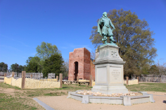
The Memorial Church, built in 1907, is constructed on the foundation of the original colonial church. Through clear sections in the floor, you can see original segments of the 400 year old foundation. Graves of some of the early colonists offer a window on the past. The 17th Century Church Tower is the last remaining above ground structure from the century which saw the founding of the colony. The original church was the site of the first representative legislative assembly in British America, so this is an important site in the history of our form of government.
Virginia has the oldest, continuous law-making body in the New World.
The Tercentenary Monument was erected in 1907, is 103 feet tall and made of New Hampshire granite. The John Smith Statue, dating from 1909, is located within the site of the first fort. It honours the man whose discipline, strong leadership, and negotiations with local Indians were vital to the survival of the colony. Smith also explored the Chesapeake Bay and rivers in the area. The Pocahontas Statue was begun in 1907, but not finished until federal funds were donated in 1913. It was dedicated in 1922. The hands of the statue are worn to a bright copper colour from the many visitors who have held the hands for souvenir pictures. The Colonial Dames of America erected the Hunt Shrine in 1922, to honour the Rev. Robert Hunt, the colony’s first Anglican minister who celebrated the first Holy Communion in the colony.
Voorhees Archaearium archaeology museum, with over 4,000 artifacts, is located on the Northwestern end of the island. Many of these artifacts came from the recent excavations at the fort site. Nearby are remnants of Confederate Fort Pocahontas. The Dale House Cafe offers refreshments with a beautiful view of the James River. The site of the Statehouse is also in this area, which is the Old Towne, the part of Jamestown owned by Preservation Virginia.
Reconstructed foundations mark the sites of many colonial period buildings. The New Towne viewer offers a glimpse of what the area might have looked like. This section features the Ambler Mansion Ruins, the May Hartwell House, the Jackson House, the Bland Warehouse, properties of Governor Yeardley, Governor Harvey, and Governor Berkeley, among others. The ruins let you imagine what scene was like when bustling with activity. Strolling the lanes of the first permanent English settlement in America is a fitting place to contemplate the streams of history which proceeded from this humble beginning.
The 3 or 5 mile driving loop around the island is a great way to see the topography the colonists faced. It is also an opportunity to see wildlife, perhaps even an American bald eagle. Though long cleared for farming, the island is slowly reverting back to forest. The Travis Estate and other historic sites are described at designated stops.
Glassblowing demonstrations at the Glasshouse show how important colonial industries were to the lives of early settlers. Visitors can see artisans use techniques from colonial times to produce items like those used by the settlers. The Jamestown Settlement, described below, adds much more in the way of crafts and skills of the colonists.
History is fun.org is the website of the state of Virginia’s Jamestown Settlement (formerly Jamestown Festival Park) and the American Revolution Museum at Yorktown (formerly Yorktown Victory Center). These sites complement the National Park Service facilities nearby. Group admissions and discount packages may be available to both sites. Parts of Jamestown Settlement have recently undergone a renovation. New historical research, more interactive exhibits, new technology, and a multimedia experiential theatre all add to the learning experience. Discovering Jamestown Electronic Classroom Adventure for teachers and students is an excellent educational resource. Reconstructions of James Fort, a Powhatan Indian Village, and the ships Susan Constant, Godspeed, and Discovery are highlights of park. The reconstructed ships have been declared “the official fleet of the Commonwealth” by the Virginia General Assembly. 2019 marks the 400th anniversary of the first representative assembly in the New World. Bottom line, there is a lot still going on in Jamestowne 300 years after the founding of the colony.
We will next take a side trip, across the James River, on the free Jamestown-Scotland Ferry, to see some other early colonial sites. From the ferry you get a view of Jamestown Island similar to what the first settlers saw as they make their way up the river. Jamestown Discovery Boat Tours also offers the chance to see the settlement from this viewpoint.
Smith’s Fort Plantation is located across the James River from Jamestown. Earthworks from 1609 remain at the site where Captain John Smith proposed a “New Fort,” which was never completed. The land was given by Chief Wahunsenacawh (Powhatan) as a dowry when his daughter Pocahontas married John Rolfe in 1614. The current manor house was built circa 1761 by Jacob Faulcon. Guided tours take less than an hour, and you have the chance to see 250 plus year old pine woodwork. The arched cupboards are a signature element in this one and a half story house. The site of the fort is on Gray’s Creek, down a dirt road.
Lightwood Plantation House, circa 1760, is just South on the road towards Surry. Located on Rocky Bottom Road, this is a highly rated rental property can accommodate up to 10 overnight guests. It is a popular wedding and event venue, with modern amenities and colonial charm. Two miles of trails ramble over the 100 acres, and the Treasure Hunt Event is sure to delight the young, and the young at heart.
Surry County Historical Society offers exhibits on local history and the Surry County Visitors Center (located in the c. 1825 Old Clerk’s Office) has useful information on historic sites and events in Surry County. Both are near the Courthouse, which has documents from the county’s founding in 1652, miraculously surviving British and Yankee invasions. A Native American youth, Chanco, warned colonists on the “Surrey Side,” saving them from the Massacre of 1622. A monument honouring him is on the Courthouse grounds. Colonial Trail East passes by on its way South to Smithfield. Taking this route will take us close to Bacon’s Castle. But first, a short trip will take us East to Chippokes Plantation State Park on the James River. Just outside Surry, turn left down State Route 634 and after a couple of miles of Surry countryside, we arrive at this large state park.
Chippokes Plantation has been a working farm since 1619. The antebellum mansion, outbuildings, and formal gardens are a step back in time to the agrarian past. The Chippokes Farm and Forestry Museum, located nearby, contributes to a better understanding of farm life, the tools and the many skills needed to keep a plantation operating smoothly. The Forestry Trail offers visitors a window on the past with a 1930’s era gas sawmill, which was used on the plantation during the timber boom. Guided tours and educational programs are offered, including ranger-led Pasture Pals program where participants help with and learn more about the care of animals such as goats, donkeys, pigs, chickens and rabbits. Chippokes Plantation State Park offers many recreational activities, including hiking, swimming, fishing, camping, and picnicking. A few cabins are also available. Hog Island Wildlife Management Area, located about a mile away on the James River, was used by colonist from Jamestown to raise hogs. Fishing, birdwatching, and seasonal hunting are popular in this tidal wetland area.
Arthur Allen, a Justice of the Peace, built Bacon’s Castle, in 1665 on land he patented in 1650. A successful planter and merchant, he built the elegant brick house late in his life when he was one of the wealthiest men in Surry County. His son, Arthur Allen ll, inherited the estate and was made a Justice of the Peace by Governor Berkeley in 1675. Allen supported Berkeley, in contrast to many of his neighbors, during Bacon’s Rebellion. Major Allen left his land and went to Jamestown, being active in efforts against the rebels. From September through December, 1676, about 70 or Bacon’s followers occupied Bacon’s Castle, and enjoyed the ‘hospitality’ of the plantation. They ransacked food, drink, and much fine linen which they found. (though they never found Allen’s silver) It is doubtful Nathaniel Bacon himself visited the site, however, the name has attached itself to the house.
Taking Route 10, Colonial Trail West, out of Surry towards Prince George County and Richmond, the countryside is part of the early expansion from Jamestown. John Martin patented the land known as Martin’s Brandon, in 1617. The extensive lands were sometimes called Upper and Lower Brandon. Lower Brandon was in the hands of the Harrison family by the 1700’s and the current house was built in 1765 by Col. Nathaniel Harrison ll for his son, Benjamin Harrison lll (whose will divided the plantation between his sons George and William) William built the Federal style main house at Upper Brandon in 1825, to which was 2 wings were added in 1859. The quality of the woodwork leads some experts to believe the craftsmen who built the house may have worked on other Virginia homes of the era, including alterations at Lower Brandon. Lower Brandon is furnished with 18th Century American and British furniture, and lovely gardens. !600 acres are still in crop production.
Near Brandon, on Hood’s Bluff overlooking the James, American’s erected Hood’s Battery. It fired on British troops under Benedict Arnold, moving upriver to burn Richmond. On their return, the British landed and were unsuccessfully attacked by George Rogers Clark. Fort Powhatan, built in the early 1800’s, occupied this site through the War of 1812, though it wasn’t attacked. Confederates again fortified this position in 1862, which was captured in 1863 by Union forces. The site is now owned by a sporting club.
James River National Wildlife Refuge is only open for special events or with advance reservations. There are limited hunting seasons and kayaking is popular. The refuge is important in preservation efforts for many species. Adjacent to the refuge is one of the oldest plantation-settlements in Virginia, Flowerdew Hundred.
Flowerdew Hundred was granted to Governor George Yeardley, in 1618, who named it for his wife’s family, the Flowerdews of Norfolk, England. It has been farmed almost continuously since that time. About 50 years ago, archaeological work began there, and thousands of artifacts have been found. The first windmill in English America was built in 1621, and a replica was built in 1978. Unfortunately, it was dismantled in recent years and the museum and grounds are currently not open to the public. Union General Grant built a pontoon bridge here to cross the move part of his army across the James River on the road to Petersburg in 1864. Near here was also Samuel Maycock’s Plantation on the James. David Meade became the owner in 1774, and it was here that Lord Cornwallis crossed in May, 1781. Later that summer, in August, Anthony Wayne also crossed here.
Adjoining Flowerdew Hundred is Merchant’s Hope, patented in 1638 by William Barker, Richard Quiney and John Sadler, merchants from London. They owned a ship, Merchant’s Hope, which was sailed between England and Virginia. Formerly Powellbrooke Plantation, Captain Nathaniel Powell and several others were killed during the 1622 massacre. Much of the land is not part of James River National Wildlife Refuge. Merchant’s Hope Church was established in the mid 17th Century, though the current building dates from 1743. The parish was part of Martin’s Brandon Parish. The Bible, which dates from 1640, is one of the oldest associated with one church. The church is a fine example of Flemish bond brickwork, and Virginia low Anglican style. The church has many interesting architectural features, such as original 18 inch square flagstone floor, well preserved compass windows, and a gracefully splayed gable roof. Nathaniel Bacon and other settlers met at the original church in 1676 to sign their petition to Governor Berkeley requesting help against Indian raids. As was often the case, Union soldiers destroyed much of the interior furnishings during their invasion of the South. It is one of the oldest Protestant churches still in use in America. The church is open by appointment. Merchant’s Hope Church is on Merchants Hope Road (State 641) less than a mile off of James River Drive (State Route 10), near Garysville.
Returning to the Jamestown side of the James River, as you leave the ferry the Virginia Capital Trail beings. It is a 52 mile bike/pedestrian trail which connects the colonial capital with today’s capital at Richmond. Scenic, with many historic markets and sites, it is a good way to see Virginia’s historic countryside. The Colonial Parkway also starts here, a ribbon connecting Jamestown with Colonial Williamsburg and Yorktown. We will follow the parkway along this segment to reach some attractions between Jamestown and Newport News. This part of the parkway offers views of Jamestown Island, Several historic plaques along this drive offer information on notable historic sites, including a failed attempt by Spanish Jesuits to establish a settlement in 1570. The area for several miles along the James River, from College Creek to Newport News, is roughly part of Martin’s Hundred, The Virginia Company, in London, sent 250 colonists to settle the area in 1619. It was one of the areas hardest hit during the Indian Massacre of 1622, and never recovered. Ivor Noel Hume, an archaeologist with Colonial Williamsburg, wrote a book about the results of the 1970’s digs in the area. Part of the settlement site is probably under Carter’s Grove and Busch Gardens.
Carter’s Grove is one of the largest of the stately old mansions along the James River. Built in 1755, by Carter Burwell, grandson of Robert “King” Carter, the mansion epitomizes the influence wielded by the large planters in colonial affairs. Restored in the 1920’s, the Colonial Williamsburg Foundation acquired it in the 1950’s. It is now in private hands, and not currently open to the public, but Colonial Williamsburg is still involved in preservation consultations and preservation of artifacts.
Busch Gardens Williamsburg (formerly Busch Gardens: Old Country and Busch Gardens Europe) is located, like Carter’s Grove, between I-64 and the James River. This land was also part of the Martin’s Hundred Plantation. This theme park is famous for its roller coasters, shows, and food. Different parts of the park represent different European countries, with food, music, rides and architecture all sharing the theme of that culture. The park is consistently rated very high for the beauty of the grounds and the popularity of the park. The adjacent Anheuser-Busch Brewery, Kingsmill Resort, and other developments have spread out and filled the area between Williamsburg and Newport News.
The paths of history which weave their way through Colonial Virginia and beyond, have their origin in Jamestown. John Smith, Pocahontas, John Rolfe, Christopher Newport, and the Chief of the Powhatan all played parts in the beginning of a new chapter in history. Ships loaded with tobacco sailed for England, and brought more settlers. As the colony of Virginia grew, more and more settlements and plantations developed, and soon the fame of Williamsburg would start to grow. Momentous events are on the horizon, and our historic tour will pick up with Williamsburg, as Virginia’s seat of government and royal authority takes center stage.